


CSV format
The comma-separated values (or CSV; also known as a comma-separated list or comma-separated variables) file format is a file type that stores tabular data.
CSV is one implementation of a delimited text file, which uses a comma to separate values (where many implementations of CSV import/export tools allow an alternate separator to be used). However, CSV differs from other delimiter separated file formats in using a " (double quote) character around fields that contain reserved characters (such as commas or newlines).
-
Each record is one line. The lines are separated with a carriage return and line feed pair.
-
Fields are separated with commas, semicolons or Tab symbol.
-
Fields with embedded commas are delimited with double-quote characters.
-
Text values are delimited with double-quote characters.
-
Fields that contain double quote characters are surrounded by double-quotes, and the embedded double-quotes are each represented by a pair of consecutive double quotes.
-
Fields with leading or trailing spaces are delimited with double-quote characters.
-
The first record in an output file is a header record containing field names.
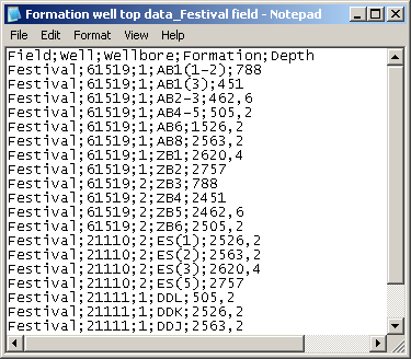
WellTracking Extension uses *. csv format to input the formation intercepts data and to work with the geoprocessing tools.
The data in the formation intercepts data file is represented by 5 fields: Field, Well, Wellbore, Formation, Depth.
-
Geoprocessing tool "Load inclination data" uses number of *.csv files with the inclination data parameters, containing following fields: ID, Field, Well, Wellbore, Geotype, Altitude, Date of measurements, as well as file with the inclination data readings, which requires Inclination data ID, Angle, Azimuth and Depth fields.
-
Geoprocessing tool "Create well sequences" uses *.csv file, containing following fields: Field, Pad, well sequence number, Altitude, Origin coordinates of the Direction of skidding the rig, Length of Direction of skidding the rig, Azimuth of Direction of skidding the rig, Catwalk length, Catwalk location relative to direction of skidding the rig.
-
Geoprocessing tool "Create pads" uses *.csv file, containing following fields: Field, Pad name, Geotype, Magnetic correction, Geometry.
-
Geoprocessing tool "Create formations" uses *.csv file, containing following fields: Code, Formation name, Depth.
-
Geoprocessing tool "Create wellbores" uses *.csv file, containing following fields: Field, Well, Wellbore number, Wellbore type, Purpose; Formation, Target-points coordinates.
*****