


Search
Objects on the map can be searched using two different options - by name and description and by location. Both types of search can be applied at a time, if needed.
Full text search
To find objects in layers and
records in tables by specific text, enter this text to the search field.
Press Search  button and then Enter. The list of objects and documents answering the
requested search parameters will be shown.
button and then Enter. The list of objects and documents answering the
requested search parameters will be shown.
Spatial search
Spatial search option is used
to find object located within specific area or at specific distance from
specific point. Press Search settings
 on the search toolbar. The spatial search filters
will be shown in the appeared window.
on the search toolbar. The spatial search filters
will be shown in the appeared window.
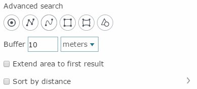
To specify the search area for searching object or document related to it, draw a point, a polyline or a polygon on your map. The following filter options are available for performing spatial search:
-
Spatial filter by point
 – allows
filtering found objects that occur in the specified location on the
map or fall inside the specified buffer zone around this point. To
learn more about drawing points see the Drawing
graphics section
– allows
filtering found objects that occur in the specified location on the
map or fall inside the specified buffer zone around this point. To
learn more about drawing points see the Drawing
graphics section -
Spatial filter by line
 –
allows
filtering found objects intersecting the specified polyline or falling
inside the specified buffer zone around the line. To learn more about
drawing polylines see the Drawing
graphics section
–
allows
filtering found objects intersecting the specified polyline or falling
inside the specified buffer zone around the line. To learn more about
drawing polylines see the Drawing
graphics section -
Spatial filter by freehand polyline
 - allows
filtering found objects intersecting the freehand polyline or falling
inside the specified buffer zone around the freehand polyline. To
learn more about drawing freehand polylines see the Drawing graphics section
- allows
filtering found objects intersecting the freehand polyline or falling
inside the specified buffer zone around the freehand polyline. To
learn more about drawing freehand polylines see the Drawing graphics section -
Spatial filter by polygon
 – allows
filtering found objects that fall inside the specified polygon or
intersect it. To learn more about drawing polygons see the Drawing
graphics section
– allows
filtering found objects that fall inside the specified polygon or
intersect it. To learn more about drawing polygons see the Drawing
graphics section -
Spatial filter by freehand polygon
 – allows
filtering found objects that fall inside the specified freehand polygon
or intersect it. To learn more about drawing freehand polygons see
the Drawing
graphics section
– allows
filtering found objects that fall inside the specified freehand polygon
or intersect it. To learn more about drawing freehand polygons see
the Drawing
graphics section -
Spatial filter by object geometry
 – allows filtering found objects that intersect
the selected map object (point, polyline or polygon) or fall inside
the specified buffer zone around the selected map object. Left-click
the object, by which you want to filter your search results.
– allows filtering found objects that intersect
the selected map object (point, polyline or polygon) or fall inside
the specified buffer zone around the selected map object. Left-click
the object, by which you want to filter your search results.
To clear spatial filter, click the Clear button .
To specify the buffer size around new point, polyline, polygon or existent map objects, enter the required value and measurement units for the Buffer parameter. The buffer zone will be shown as graphic on the map to visualize your search results.
Press Search button and the list of objects answering the requested parameters will be shown.
Extend search area to first result option can be used, if no objects or documents were found in the result of the advanced search. To enable this option check the box near the Extend search area to first result line in the Spatial filter dialog. Thus the system will search for the specified objects or documents, continuously extending the search area until the first object or document that meet the search query is found. The obtained result will be added to the search results list.
Besides, the search results list can be sorted by distance to specific object. To specify such object, check the Sort by distance option and open its menu. Select the required objects from the appeared list.
Working with the search results list
The search results are shown as a drop-down list of objects grouped by map layers and tables. To zoom your map view to a specific found object and open its identification dialog, click on this object in the search results list.
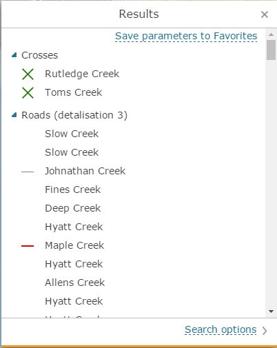
For users with the catalog editing permissions the Save parameters to favorites button is available, which allows saving current search settings as template used to create quick search buttons in constructor.
Setting search parameters in selected layers and tables
The
full-text search can be performed for either all layers or tables, or
for selected layer or table. To specify the layer for search, go
to Search settings menu  and use Where
to search option to select the required search variant from the
list:
and use Where
to search option to select the required search variant from the
list:
-
All layers and tables - search will be performed in all map layers
-
All visible layers and tables - search will be performed in visible map layers only
-
Selected layers and tables - search will be performed only in the selected layers in the list. To select all layers in the list, click the All layers option. To select only visible layers, click the All visible layers option. To deselect all layers, click Clear selection button.
If there is a geocoding service in the services list of your interactive map, the search by address option will be available. To disable the search by address option, uncheck the box for the Search by address option.
If your map contains a large number of layers, and you want to perform your search within some specific layers only, use the search by layers option. To do so, enter the part of the layer's name in the layer search field and the list of layers will be filtered.
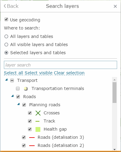
To get back to search settings, press Back button.
Quick search buttons
Quick search buttons are displayed on Search tab if they have been specified for this map. Click Search button to start search.