


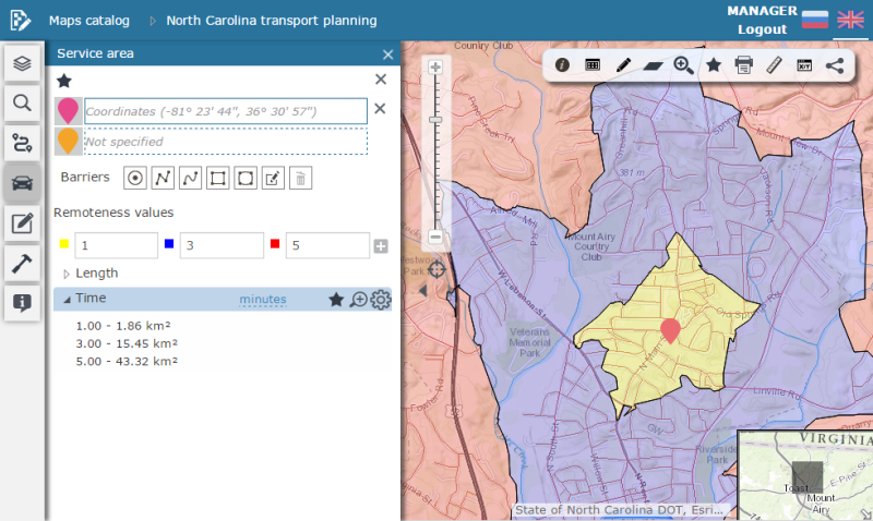
Calculating service area
The Service area tool allows to:
-
Create service areas for one or several points
-
Specify different remoteness values
-
Perform calculation considering barriers.
To calculate service area, specify one or multiple source points:
-
Add point to map – to add new source point to the map, click the pushpin icon
 in the Service area dialog, then left-click the required point on
your map. The point coordinates will be added to the field and the
bubble icon will appear on the map.
in the Service area dialog, then left-click the required point on
your map. The point coordinates will be added to the field and the
bubble icon will appear on the map. -
Add point by address – to add point by address, enter the address in the field and select the required address from the drop-down list. The mark of the point will be shown in the appropriate place on the map.
To delete the source point, click the Remove
point  button near the point. To delete all
points, click the Remove all source points
and barriers button.
button near the point. To delete all
points, click the Remove all source points
and barriers button.
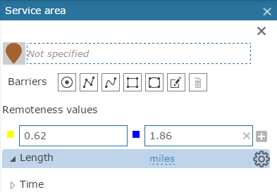
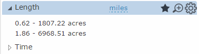
To calculate service areas, the remoteness value must be indicated.
The remoteness value is a parameter, that allows to estimate the territory
in terms of time spent to cover the service area or distance from specified
point. The remoteness can be specified by the route length (in meters)
and by time required to reach the destination point (in minutes). To add
new remoteness value, click the Add remoteness
value  button. The new element will be added
to the list of values. Enter the required remoteness value to the
field.
button. The new element will be added
to the list of values. Enter the required remoteness value to the
field.
As a result, the service area will be shown on the map according to specified parameters.
Barriers
To be able to mark road obstructions on your route (e.g., road closures), add the barrier parameter to your search. To add new barrier, select its type. The system allows creating point, polyline and polygon barriers:
-
To add point barrier, select the Draw barrier by point
 option and left-click the point on the map and the point barrier will
be created.
option and left-click the point on the map and the point barrier will
be created. -
To add polyline barrier, select the Draw barrier by polyline
 option. Draw barrier nodes by left-clicking in the appropriate map
places, finish the drawing by double left-click. The polyline barrier
will be created.
option. Draw barrier nodes by left-clicking in the appropriate map
places, finish the drawing by double left-click. The polyline barrier
will be created. -
To add freehand polyline barrier, select the Draw barrier by freehand polyline
 option.
Draw the barrier by dragging the cursor on the map with the left mouse
button. Release the mouse button and finish editing. The barrier will
be created.
option.
Draw the barrier by dragging the cursor on the map with the left mouse
button. Release the mouse button and finish editing. The barrier will
be created. -
To add polygon barrier, select the Draw barrier by polygon
 option. Draw the barrier nodes by left-clicking in the appropriate
map places, and double click to finish drawing. The barrier will be
created.
option. Draw the barrier nodes by left-clicking in the appropriate
map places, and double click to finish drawing. The barrier will be
created. -
To add freehand polygon barrier, select the Draw barrier by freehand polygon
 option. Draw
the barrier on the map by dragging the cursor on the map with the
left mouse button. Release the mouse button and finish editing. The
barrier will be created.
option. Draw
the barrier on the map by dragging the cursor on the map with the
left mouse button. Release the mouse button and finish editing. The
barrier will be created.
To delete all barriers, click the Remove
 button.
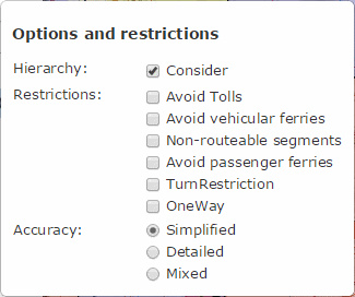
Options and restrictions
Different services and their remoteness values can be used for creating service areas in the system. All combinations of services and remoteness values are shown in the list. By default the first set of parameters from the list is used for the area calculation. To calculate areas by other set of parameters, click it in the list. It's important to take into account that not all services provide the barriers consideration option.
To consider different options and services restrictions when calculating
the service area, click the Options and
restrictions  button and select the required
options and restrictions in the appeared window:
button and select the required
options and restrictions in the appeared window:
To add all service areas parameters to favorites click the Favorites
 button. To zoom to the map and show the whole
service area, click the Zoom
button. To zoom to the map and show the whole
service area, click the Zoom  button.