


Searching optimal route
The Optimal route search option allows to:
-
Calculate route by any number of points
-
Consider barriers
-
Select services for the route calculation.

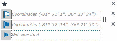
To calculate the route, specify two or more destination points as search parameters. There are some ways for adding the destination points as search parameters:
-
Add destination point on map – to add new destination point on map, click any
 mark in the points list, then left-click the required point on the
map. The destination point will be added to the list and shown on
the map.
mark in the points list, then left-click the required point on the
map. The destination point will be added to the list and shown on
the map. -
Add destination point by address – to add destination point by address, enter the address in the appropriate field. The new empty element will be added to the destination points list. Start entering the address in the field and select the required address from the drop-down list. The destination point mark will appear in the correspondent point on the map.
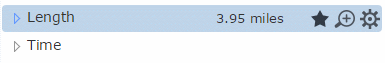
After the route has been determined, it will be shown as a highlighted polyline on the map. You can also see the detailed information about the route's streets and length. To display the whole route on the map click the Zoom button.
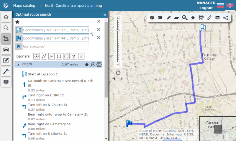
To delete the destination point, click the Remove
point  button near the appropriate
destination point in the list. To delete all items and clear parameters,
click the Remove all destination points
and barriers button. To change the destination
points order in the list, drag the required point up/down or click the
Swap stops
button near the appropriate
destination point in the list. To delete all items and clear parameters,
click the Remove all destination points
and barriers button. To change the destination
points order in the list, drag the required point up/down or click the
Swap stops  button.
To add input route points to favorites, click the Favorites
button.
To add input route points to favorites, click the Favorites
 button.
To change location of the destination point, click it and move to other position. The route will be recalculated accordingly. To add new point to the existing route on the map, drag any route turn, and new point will be added in the editable format.
Barriers
To be able to mark road obstructions on your route (e.g., road closures), add the barrier parameter to your search. To add new barrier, select its type. The system allows creating point, polyline and polygon barriers:
-
To add point barrier, select the Draw barrier by point
 option and left-click the point on the map and the point barrier will
be created.
option and left-click the point on the map and the point barrier will
be created. -
To add polyline barrier, select the Draw barrier by polyline
 option. Draw barrier nodes by left-clicking in the appropriate map
places, finish the drawing by double left-click. The polyline barrier
will be created.
option. Draw barrier nodes by left-clicking in the appropriate map
places, finish the drawing by double left-click. The polyline barrier
will be created. -
To add freehand polyline barrier, select the Draw barrier by freehand polyline
 option.
Draw the barrier by dragging the cursor on the map with the left mouse
button. Release the mouse button and finish editing. The barrier will
be created.
option.
Draw the barrier by dragging the cursor on the map with the left mouse
button. Release the mouse button and finish editing. The barrier will
be created. -
To add polygon barrier, select the Draw barrier by polygon
 option. Draw the barrier nodes by left-clicking in the appropriate
map places, and double click to finish drawing. The barrier will be
created.
option. Draw the barrier nodes by left-clicking in the appropriate
map places, and double click to finish drawing. The barrier will be
created. -
To add freehand polygon barrier, select the Draw barrier by freehand polygon
 option. Draw
the barrier on the map by dragging the cursor on the map with the
left mouse button. Release the mouse button and finish editing. The
barrier will be created.
option. Draw
the barrier on the map by dragging the cursor on the map with the
left mouse button. Release the mouse button and finish editing. The
barrier will be created.
To delete all barriers, click the Remove
 button.
Route options and restrictions
Depending on the interactive map settings, the route can be created using different networks and their calculation types. Every combination of the network and its calculation type is shown in the list of possible routes. By default the first route is created by the first parameters set from the list. To create the route by different parameters set, select it in the list. The route will be created.
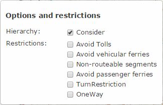
To create additional options and restrictions, click the Options
and restrictions  button
in the created route dialog. In the dialog check the box near the options
and restrictions you want to be considered by the route calculation.
button
in the created route dialog. In the dialog check the box near the options
and restrictions you want to be considered by the route calculation.
To add the created route to favorites, click the Favorites
button. To zoom to the map and show the whole
route, click the Zoom  button.