


Step 2. Inclination data
At this step you must specify the well and parameters to be used for constructing the wellbore geometry.
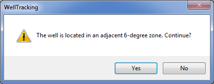
Select mine take corresponding to your feature. If the feature crosses the mine take borders, the appropriate warning message will appear.
The following types of wellbore geometries can be specified:

When specifying “Inclination” as a data type and “Temporary” for the inclination measurement, the magnetic correction value taken from the inclination measurement summary or specified by the user is automatically considered for calculation of these wellbore geometries types. The Use for calculating wellbore geometry option will be disabled. The value of the magnetic correction taken from the file name or specified by the user will be added to the MAGNETIC_CORRECTION column of the WELLBORE_GEOMETRY attribute table.
While loading data of ‘Design plan’ geotype, the wellbore trajectory behaves as the project wellbore, and it is impossible to build intersection points by this trajectory. Besides, after deletion of actual measurement, this wellbore does not become actual.
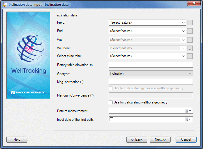
To specify the Gyroscope measurement value you need to know the azimuth type (either magnetic or geographic) specified in the measurement file.
- In case if the magnetic azimuth is used in the Gyroscope measurement files, the magnetic correction should be considered when calculating the wellbore geometry. So, the Use for calculating wellbore geometry option should be checked. The value of the magnetic correction taken from the inclination measurement summary or one specified by the user in the Mag. correction field will be added to the MAGNETIC_CORRECTION column of the WELLBORE_GEOMETRY attribute table.
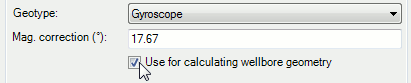
- In case if the geographic azimuth is used, the value of the magnetic correction is automatically considered and specified in the text file. So, it is not correct to use the magnetic correction value again for later calculations. In this case it is NOT recommended to check the Use for calculating wellbore geometry option. The magnetic correction value taken from the measurement summary will be not considered by gyroscope geometry calculation.
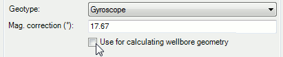
- The Meridian convergence parameter is calculated automatically just after the tool dialog is filled in with the well data. You can select to consider this parameter or not by checking/unchecking the Use for calculating wellbore geometry option.
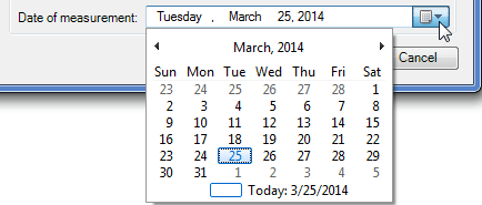
The Date of measurement line is filled in automatically from the input text file header or by specifying the date using the calendar:
-
If the user specified the Copy from the clipboard at the previous step, he should fill in this dialogue by himself.
-
If you add wellbore geometry from text file, then the Inclination data dialog will be filled in automatically based on parameters specified in the text file title. The remaining parameters should be specified manually by the user.
·
-
If you add wellbore geometry from shapefile, all parameters should be specified manually. If you want to add wellbore geometry for archive well, use the appropriate Select buttons located near the Pad, Well, and Wellbore combo boxes. Press the button and click the required object on the map, the tool dialog will be filled in automatically.
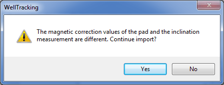
In case of entering incorrect data the respective warning messages appear:
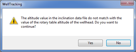
Hint: values for the magnetic correction and the rotary table altitude are taken from the inclination measurement file.
The Next button becomes active only upon completion the data correction in the selected rows.
Click Next to move to the next step, or Cancel to exit the Inclination data input tool dialog.
*****