


WellTracking geodatabase scheme
1. WellTracking data
1. 1. Spatial and table data
1. 2. Inclination data
1. 3. Data for reports generation
1. 4. Data for access management
1. 5. Configuration data
1. 6. Data to save layer properties
1. 7. Domains
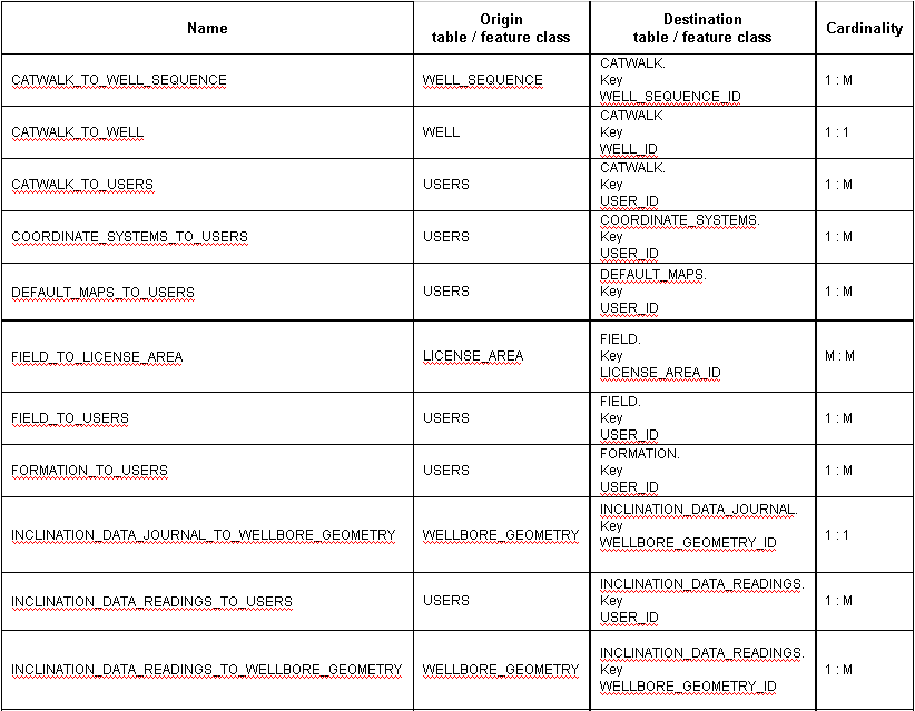
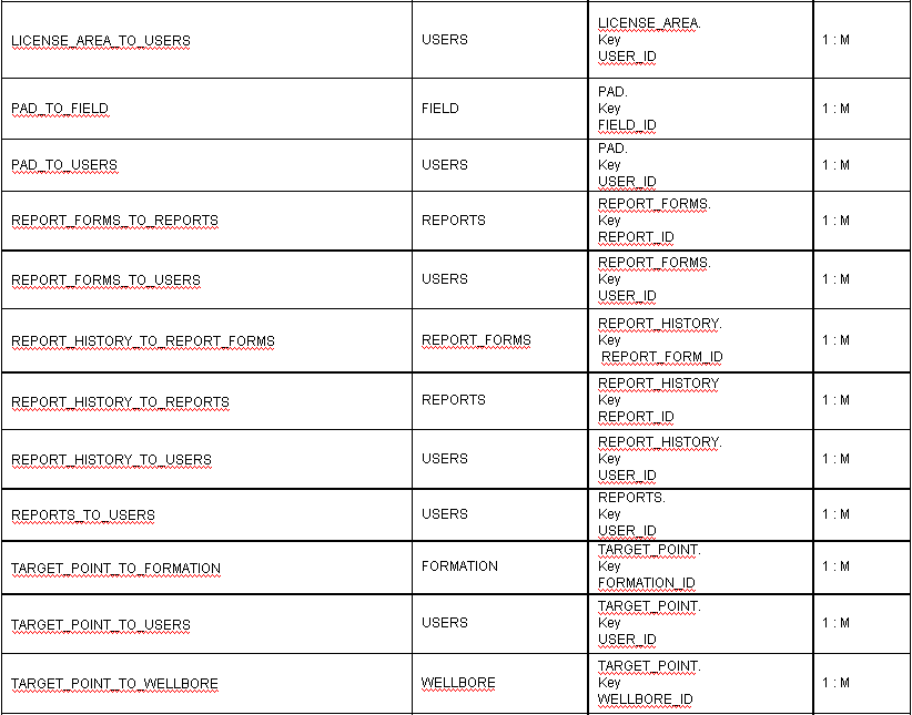
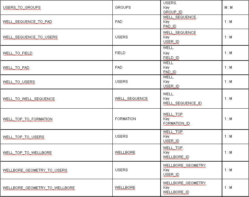
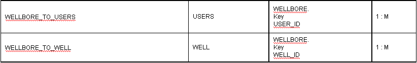
1. 8. Relationship classes
2. WellTracking data history
2. 1. Spatial and table data history
2. 2. Data for access management history
2. 3. Configuration data history
2.4. Relationship classes of WellTracking data history
1. WellTracking data
1. 1. Spatial and table data
LICENSE_AREA – License area
|
Field |
Field type |
Description |
|
OBJECTID |
OBJECTID |
Identifier |
|
USER_ID |
LONG |
User identifier. Relate to USER.OBJECTID |
|
NAME
|
TEXT |
License area name |
|
MODIFICATION_UTC_TIME |
DATE |
Modification date |
|
GEOTYPE |
LONG (LICENSE_AREA_GEOTYPE domain) |
License area geotype |
|
STATUS |
LONG (LICENSE_AREA_STATUS domain) |
License area status |
|
SHAPE |
GEOMETRY |
Geometry |
PAD – Pad area
|
Field |
Field type |
Description |
|
OBJECTID |
OBJECTID |
Identifier |
|
USER_ID |
LONG |
User identifier. Relate to USER.OBJECTID |
|
NAME |
TEXT |
Pad area name |
|
MAGNETIC_CORRECTION |
DOUBLE |
Pad area magnetic correction |
|
FIELD_ID |
LONG |
Field identifier. Relate to FIELD.OBJECTID |
|
MODIFICATION_UTC_TIME |
DATE |
Modification date |
|
STATUS |
LONG (PAD_STATUS domain) |
Pad area status |
|
SHAPE |
GEOMETRY |
Geometry |
CATWALK - Catwalk
|
Field |
Field type |
Description |
|
OBJECTID |
OBJECTID |
Identifier |
|
USER_ID |
LONG |
User identifier. Relate to USER.OBJECTID |
|
WELL_SEQUENCE_ID |
LONG |
Well sequence identifier. Relate to WELL_SEQUENCE.OBJECTID |
|
WELL_ID |
LONG |
Well identifier. Relate to WELL.OBJECTID |
|
MODIFICATION_UTC_TIME |
DATE |
Modification date |
|
SHAPE |
GEOMETRY |
Geometry |
WELL – Well
|
Field |
Field type |
Description |
|
OBJECTID |
OBJECTID |
Identifier |
|
USER_ID |
LONG |
User identifier. Relate to USER.OBJECTID |
|
WELL_NUMBER |
TEXT |
Well number |
|
WELL_HEAD_NUMBER |
LONG |
Well head number on well sequence |
|
FIELD_ID |
LONG |
Field identifier. Relate to FIELD.OBJECTID |
|
PAD_ID |
LONG |
Pad identifier. Relate to PAD.OBJECTID |
|
WELL_SEQUENCE_ID |
LONG |
Well sequence identifier. Relate to WELL_SEQUENCE.OBJECTID |
|
MODIFICATION_UTC_TIME |
DATE |
Modification date |
|
STATUS
|
LONG (WELL_STATUS domain) |
Well status
|
|
RIG_SKIDDING |
DOUBLE |
Skidding of drilling rig |
|
MRK_FLANGE |
DOUBLE |
Flange mark |
|
MRK_ROTOR |
DOUBLE |
Rotor mark |
|
SHAPE |
GEOMETRY |
Geometry |
TARGET_POINT – Target-point
|
Field |
Field type |
Description |
|
OBJECTID |
OBJECTID |
Identifier |
|
USER_ID |
LONG |
User identifier. Relate to USER.OBJECTID |
|
FORMATION_ID |
LONG |
Formation identifier. Relate to FORMATION.OBJECTID |
|
WELLBORE_ID |
LONG |
Wellbore identifier. Relate to WELLBORE.OBJECTID |
|
GEOTYPE |
LONG (TARGET_POINT_GEOTYPE domain) |
Target-point geotype |
|
MODIFICATION_UTC_TIME |
DATE |
Modification date |
|
STATUS |
LONG (WELL_STATUS domain) |
Target-point status |
|
SHAPE |
GEOMETRY |
Geometry |
WELL_TOP – Formation intercepts
|
Field |
Field type |
Description |
|
OBJECTID |
OBJECTID |
Identifier |
|
USER_ID |
LONG |
User identifier. Relate to USER.OBJECTID |
|
FORMATION_ID |
LONG |
Formation identifier. Relate to FORMATION.OBJECTID |
|
WELLBORE_ID |
LONG |
Wellbore identifier. Relate to WELLBORE.OBJECTID |
|
DEPTH |
DOUBLE |
Drilling depth of formation intercepts |
|
ABS_H |
DOUBLE |
Absolute depth of formation intercepts |
|
GEOTYPE |
LONG |
Geotype of formation intercepts |
|
MODIFICATION_UTC_TIME |
DATE |
Modification date |
|
SHAPE |
GEOMETRY |
Geometry |
WELLBORE_GEOMETRY – Wellbore geometry
|
Field |
Field type |
Description |
|
OBJECTID |
OBJECTID |
Identifier |
|
USER_ID |
LONG |
User identifier. Relate to USER.OBJECTID |
|
WELLBORE_ID |
LONG |
Wellbore identifier. Relate to WELLBORE.OBJECTID |
|
STATUS |
LONG (WELLBORE_GEOMETRY_STATUS domain) |
Wellbore geometry status |
|
MEASUREMENT_DATE |
DATE |
Measurement date |
|
GEOTYPE |
LONG (WELLBORE_GEOMETRY_GEOTYPE domain) |
Wellbore geometry geotype |
|
MAGNETIC_CORRECTION |
DOUBLE |
Magnetic correction value
|
|
MODIFICATION_UTC_TIME |
DATE |
Modification date |
| MERIDIAN_CONVERGENCE |
DOUBLE |
Meridian convergence value |
|
SHAPE |
GEOMETRY |
Geometry |
WELL_SEQUENCE - Well sequence
|
Field |
Field type |
Description |
|
OBJECTID |
OBJECTID |
Identifier |
|
USER_ID |
LONG |
User identifier. Relate to USER.OBJECTID |
|
WELL_SEQUENCE_NUM |
LONG |
Well sequence number |
|
ALTITUDE |
DOUBLE |
Well sequence altitude |
|
PAD_ID |
LONG |
Pad area identifier. Relate to PAD.OBJECTID |
|
STATUS
|
LONG (WELL_SEQUENCE_STATUS domain) |
Well sequence status
|
|
MODIFICATION_UTC_TIME |
DATE |
Modification date |
|
SHAPE |
GEOMETRY |
Geometry |
WELLBORE – Wellbore
|
Field |
Field type |
Description |
|
OBJECTID |
OBJECTID |
Identifier |
|
USER_ID |
LONG |
User identifier. Relate to USER.OBJECTID |
|
WELL_ID |
LONG |
Well identifier. Relate to WELL.OBJECTID |
|
WELLBORE_NUM |
LONG |
Wellbore number |
|
MODIFICATION_UTC_TIME |
DATE |
Modification date |
|
STATUS |
LONG (WELLBORE_STATUS domain) |
Wellbore status |
|
PROFILE |
LONG (WELLBORE_PROFILE domain) |
Wellbore profile |
|
PURPOSE |
LONG (WELLBORE_PURPOSE domain) |
Wellbore purpose
|
|
NAME |
TEXT |
Wellbore purpose |
|
PILOT_NUM |
TEXT |
Pilot wellbore number |
|
EMERGENCY_WELLBORE_NUM |
TEXT |
Number of wellbore abandoned when drilling failure |
FIELD - Field
|
Field |
Field type |
Description |
|
OBJECTID |
OBJECTID |
Identifier |
|
USER_ID |
LONG |
User identifier. Relate to USER.OBJECTID |
|
NAME |
TEXT |
Field name |
|
MODIFICATION_UTC_TIME |
DATE |
Modification date |
|
MAGNETIC_CORRECTION |
DOUBLE |
Field magnetic correction value |
FORMATION - Formation
|
Field |
Field type |
Description |
|
OBJECTID |
OBJECTID |
Identifier |
|
USER_ID |
LONG |
User identifier. Relate to USER.OBJECTID |
|
FORMATION_NAME |
TEXT |
Formation name |
|
DEPTH |
DOUBLE |
Formation occurrence absolute depth |
|
CODE |
TEXT |
Formation code |
|
MODIFICATION_UTC_TIME |
DATE |
Modification date |
1. 2. Inclination data
INCLINATION_DATA_JOURNAL – Inclination data journal
|
Field |
Field type |
Description |
|
OBJECTID |
OBJECTID |
Identifier |
|
EXTENSION |
TEXT |
Input file extension |
|
ORIGINAL_FILENAME |
TEXT |
Input file name |
|
FILE_DATA |
BLOB |
Input file data (file with inclination data measurement) |
|
UTC_CREATION_TIME |
DATE |
Loading date |
|
WELLBORE_GEOMETRY_ID |
LONG |
Wellbore geometry identifier. Relate to WELLBORE_GEOMETRY.OBJECTID |
|
USER_ID |
LONG |
User identifier. Relate to USER.OBJECTID |
|
MODIFICATION_UTC_TIME |
DATE |
Modification date |
INCLINATION_DATA_READINGS - Inclination data readings
|
Field |
Field type |
Description |
|
OBJECTID |
OBJECTID |
Identifier |
|
USER_ID |
LONG |
User identifier. Relate to USER.OBJECTID |
|
MODIFICATION_UTC_TIME |
DATE |
Modification date |
|
WELLBORE_GEOMETRY_ID |
LONG |
Wellbore geometry identifier. Relate to WELLBORE_GEOMETRY.OBJECTID |
|
INCL |
DOUBLE |
Vertical deviation angle |
|
AZM |
DOUBLE |
Azimuth |
|
DEPTH |
DOUBLE |
Drilled depth |
|
DX |
DOUBLE |
X- Closure |
|
DY |
DOUBLE |
Y- Closure |
|
ABS_H |
DOUBLE |
Absolute depth |
1. 3. Data for reports generation
REPORT_FORMS – Report forms
|
Field |
Field type |
Description |
|
OBJECTID |
OBJECTID |
Identifier |
|
USER_ID |
LONG |
User identifier. Relate to USER.OBJECTID |
|
MODIFICATION_UTC_TIME |
DATE |
Modification date |
|
REPORT_ID |
LONG |
Report identifier. Relate to REPORT.OBJECTID |
|
REPORT_FORM |
BLOB |
Data |
|
REPORT_FORM_TYPE |
TEXT |
Report form format (MS Word, MS Excel files) |
|
FORM_NAME |
TEXT |
Report form name |
COORDINATE_SYSTEMS – Coordinate systems
|
Field |
Field type |
Description |
|
OBJECTID |
OBJECTID |
Identifier |
|
USER_ID |
LONG |
User identifier. Relate to USER.OBJECTID |
|
NAME |
TEXT |
Coordinate system name |
|
DATA |
BLOB |
Data (*.prj file) |
|
MODIFICATION_UTC_TIME |
DATE |
Modification date |
REPORT_HISTORY – Reports history
|
Field |
Field type |
Description |
|
OBJECTID |
OBJECTID |
Identifier |
|
USER_ID |
LONG |
User identifier. Relate to USER.OBJECTID |
|
MODIFICATION_UTC_TIME |
DATE |
User identifier |
|
REPORT_DESCRIPTION |
TEXT |
Report description |
|
REPORT_DATA |
BLOB |
Data (report file) |
|
REPORT_FORM_ID |
LONG |
Report form identifier. Relate to REPORT_FORMS.OBJECTID |
|
REPORT_ID |
LONG |
Report identifier. Relate to REPORTS.OBJECTID |
REPORTS - Reports
|
Field |
Field type |
Description |
|
OBJECTID |
OBJECTID |
Identifier |
|
USER_ID |
LONG |
User identifier. Relate to USER.OBJECTID |
|
MODIFICATION_UTC_TIME |
DATE |
Modification date |
|
REPORT_NAME |
TEXT |
Report name |
1. 4. Data for access management
GROUPS – User groups
|
Field |
Field type |
Description |
|
OBJECTID |
OBJECTID |
Identifier |
|
GROUPNAME |
TEXT |
Group name |
|
COMMANDS |
BLOB |
List of available commands |
USERS - Users
|
Field |
Field type |
Description |
|
OBJECTID |
OBJECTID |
Identifier |
|
USERNAME |
TEXT |
User name |
|
PASSWORDHASH |
TEXT |
Hash function value and password |
|
DESCRIPTION |
TEXT |
User description |
1. 5. Configuration data
CONFIG – Configuration table
|
Field |
Field type |
Description |
|
OBJECTID |
OBJECTID |
Identifier |
|
PROPERTYNAME |
TEXT |
Name |
|
PROPERTYVALUE |
TEXT |
Value |
DEFAULT_MAPS - Maps
|
Field |
Field type |
Description |
|
OBJECTID |
OBJECTID |
Identifier |
|
USER_ID |
LONG |
User identifier. Relate to USER.OBJECTID |
|
MODIFICATION_UTC_TIME |
DATE |
Modification date |
|
MAPNAME |
TEXT |
Map name |
|
MAPDATA |
BLOB |
Data (*.mxd file) |
1. 6. Data to save layer properties
WellTrackingToCltemInfo - Table of saved symbology and filtration parameters
|
Field |
Field type |
Description |
|
OBJECTID |
OBJECTID |
Identifier |
| ToCItemName | TEXT |
Name of data source, for which the layer properties are saved |
| SettingCaption | TEXT |
Name of saved layer or table |
|
ToCItemInfo |
BLOB |
Layer properties |
1. 7. Domains
TARGET_POINT_GEOTYPE – Target-point geotype
Fields: TARGET_POINT .GEOTYPE. Fields type: LONG.
|
Code |
Description |
|
-1 |
Unknown |
|
0 |
t1 |
|
1 |
t2 |
|
3 |
Bottomhole |
|
4 |
t3 |
|
5 |
t4 |
|
6 |
t5 |
|
7 |
t6 |
|
8 |
t7 |
|
9 |
t8 |
|
10 |
t9 |
|
11 |
t10 |
|
12 |
t11 |
|
13 |
t12 |
WELL_STATUS – Well status
Fields: TARGET_POINT.STATUS, WELL.STATUS. Fields type LONG.
|
Code |
Description |
|
-1 |
Unknown |
|
0 |
Project |
|
1 |
In the process of drilling |
|
2 |
Active |
|
3 |
Abandoned |
|
4 |
Suspended |
PAD_STATUS – Pad status
Fields: PAD.STATUS. Fields type LONG.
|
Code |
Description |
|
-1 |
Unknown |
|
0 |
Project |
|
1 |
In the process of drilling |
|
2 |
Active |
|
3 |
Abandoned |
WELL_SEQUENCE_STATUS – Well sequence status
Fields: WELL_SEQUENCE.STATUS. Fields type LONG.
|
Code |
Description |
|
-1 |
Unknown |
|
0 |
Project |
|
1 |
Active |
WELLBORE_GEOMETRY_STATUS – Wellbore geometry status
Fields: WELLBORE_GEOMETRY.STATUS. Fields type LONG.
|
Code |
Description |
|
-1 |
Unknown |
|
0 |
Archive |
|
1 |
Active |
WELLBORE_GEOMETRY_GEOTYPE – Wellbore geometry geotype
Field: WELLBORE_GEOMETRY.GEOTYPE. Fields type LONG.
|
Code |
Description |
|
-1 |
Unknown |
|
0 |
Project |
|
1 |
Inclination |
|
2 |
Gyroscope |
|
3 |
Gyroscope-correction |
|
4 |
Temporary measurement |
|
5 |
Design-plan |
WELLBORE_PROFILE – Wellbore profile
Fields: WELLBORE.PROFILE. Fields type LONG.
|
Code |
Description |
|
-1 |
Unknown |
|
0 |
Vertical |
|
1 |
Horizontal |
|
2 |
Deviated |
WELLBORE_STATUS – Wellbore status
Fields: WELLBORE.STATUS. Fields type LONG.
|
Code |
Description |
|
-1 |
Unknown |
|
0 |
Project |
|
1 |
In the process of drilling |
|
2 |
Active |
|
3 |
Abandoned when drilling failure |
|
4 |
Abandoned after drilling |
|
5 |
Abandoned when operating |
|
6 |
Abandoned after operation |
|
7 |
Suspended |
|
8 |
Idle |
|
9 |
Injecting |
|
10 |
Monitoring |
WELLBORE_PURPOSE – Wellbore purpose
Fields: WELLBORE.PURPOSE. Fields type LONG.
|
Code |
Description |
|
-1 |
Unknown |
|
0 |
Producing |
|
1 |
Injecting |
|
2 |
Exploratory |
|
3 |
Prospecting |
|
4 |
Control-piestic |
|
5 |
Pilot |
|
6 |
Monitoring |
LICENSE_AREA_GEOTYPE – License area geotype
Fields: GEOTYPE. Fields type LONG.
|
Code |
Description |
|
-1 |
Unknown |
|
0 |
License area |
|
1 |
Mine take |
LICENSE_AREA_STATUS – License area status
Fields: STATUS. Fields type LONG.
|
Code |
Description |
|
-1 |
Unknown |
|
0 |
Archive |
|
1 |
Active |
WELL_TOP_GEOTYPE – Formation intercepts geotype
Field: WELL_TOP_GEOTYPE. Fields type LONG.
|
Code |
Description |
|
-1 |
Unknown |
|
0 |
Formation top intercept |
|
1 |
Formation bottom intercept |
1.8. Relationship classes
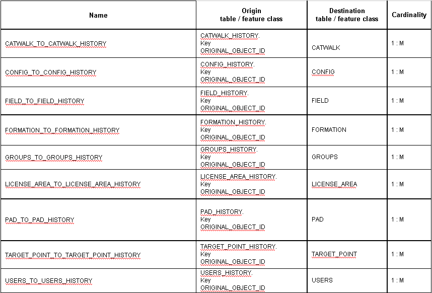
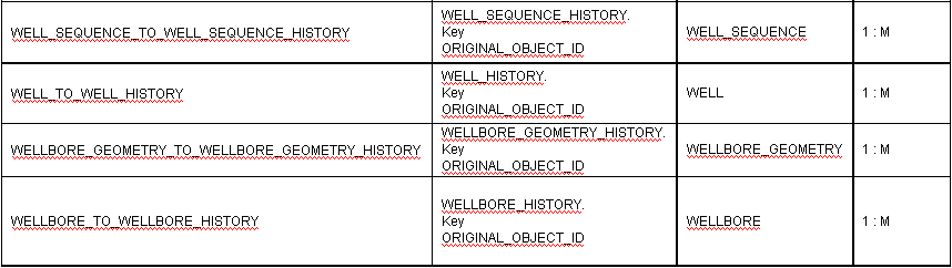
2. WellTracking data history
2. 1. Spatial and table data history
LICENSE_AREA_HISTORY – License area history
|
Field |
Field type |
Description |
|
OBJECTID |
OBJECTID |
License area history identifier |
|
USER_ID |
LONG |
User identifier. Relate to USER.OBJECTID |
|
NAME
|
TEXT |
License area name |
|
MODIFICATION_UTC_TIME |
DATE |
Modification date |
|
GEOTYPE |
LONG (LICENSE_AREA_GEOTYPE domain) |
License area geotype |
|
STATUS |
LONG (LICENSE_AREA_STATUS domain) |
License area status |
|
EDITING_START_DATE |
DATE |
Editing start date |
|
EDITING_END_DATE |
DATE |
Editing end date |
|
ORIGINAL_OBJECTID |
LONG |
License_area identifier. Relate to LICENSE_AREA.OBJECTID |
|
SHAPE |
GEOMETRY |
Geometry |
PAD_HISTORY – Pad area history
|
Field |
Field type |
Description |
|
OBJECTID |
OBJECTID |
Pad history identifier |
|
USER_ID |
LONG |
User identifier. Relate to USER.OBJECTID |
|
NAME |
TEXT |
Pad area name |
|
MAGNETIC_CORRECTION |
DOUBLE |
Pad area magnetic correction |
|
FIELD_ID |
LONG |
Field identifier. Relate to FIELD.OBJECTID |
|
MODIFICATION_UTC_TIME |
DATE |
Modification date |
|
STATUS |
LONG (PAD_STATUS domain) |
Pad area status |
|
EDITING_START_DATE |
DATE |
Editing start date |
|
EDITING_END_DATE |
DATE |
Editing end date |
|
ORIGINAL_OBJECTID |
LONG |
Pad area identifier. Relate to PAD.OBJECTID |
|
SHAPE |
GEOMETRY |
Geometry |
CATWALK_HISTORY - Catwalk history
|
Field |
Field type |
Description |
|
OBJECTID |
OBJECTID |
Catwalk history identifier |
|
USER_ID |
LONG |
User identifier. Relate to USER.OBJECTID |
|
WELL_SEQUENCE_ID |
LONG |
Well sequence identifier. Relate to WELL_SEQUENCE.OBJECTID |
|
WELL_ID |
LONG |
Well identifier. Relate to WELL.OBJECTID |
|
MODIFICATION_UTC_TIME |
DATE |
Modification date |
|
EDITING_START_DATE |
DATE |
Editing start date |
|
EDITING_END_DATE |
DATE |
Editing end date |
|
ORIGINAL_OBJECTID |
LONG |
Catwalk identifier. Relate to CATWALK.OBJECTID |
|
SHAPE |
GEOMETRY |
Geometry |
WELL_HISTORY – Well history
|
Field |
Field type |
Description |
|
OBJECTID |
OBJECTID |
Well history identifier |
|
USER_ID |
LONG |
User identifier. Relate to USER.OBJECTID |
|
WELL_NUMBER |
TEXT |
Well number |
|
WELL_HEAD_NUMBER |
LONG |
Well head number on well sequence |
|
FIELD_ID |
LONG |
Field identifier. Relate to FIELD.OBJECTID |
|
PAD_ID |
LONG |
Pad area identifier. Relate to PAD.OBJECTID |
|
WELL_SEQUENCE_ID |
LONG |
Well sequence identifier. Relate to WELL_SEQUENCE.OBJECTID |
|
MODIFICATION_UTC_TIME |
DATE |
Modification date |
|
STATUS
|
LONG (WELL_STATUS domain) |
Well status
|
|
RIG_SKIDDING |
DOUBLE |
Skidding of drilling rig |
|
FLANGE_MRK |
DOUBLE |
Flange mark |
|
ROTOR_MRK |
DOUBLE |
Rotor mark |
|
EDITING_START_DATE |
DATE |
Editing start date |
|
EDITING_END_DATE |
DATE |
Editing end date |
|
ORIGINAL_OBJECTID |
LONG |
Well identifier. Relate to WELL.OBJECTID |
|
SHAPE |
GEOMETRY |
Geometry |
TARGET_POINT_HISTORY – Target-point history
|
Field |
Field type |
Description |
|
OBJECTID |
OBJECTID |
Target-point history identifier |
|
USER_ID |
LONG |
User identifier. Relate to USER.OBJECTID |
|
FORMATION_ID |
LONG |
Formation identifier. Relate to FORMATION.OBJECTID |
|
WELLBORE_ID |
LONG |
Wellbore identifier. Relate to WELLBORE.OBJECTID |
|
GEOTYPE |
LONG (TARGET_POINT_GEOTYPE domain) |
Target-point geotype |
|
MODIFICATION_UTC_TIME |
DATE |
Modification date |
|
STATUS |
LONG (WELL_STATUS domain) |
Target-point status |
|
EDITING_START_DATE |
DATE |
Editing start date |
|
EDITING_END_DATE |
DATE |
Editing end date |
|
ORIGINAL_OBJECTID |
LONG |
Target-point identifier. Relate to TARGET_POINT.OBJECTID |
|
SHAPE |
GEOMETRY |
Geometry |
WELL_TOP_HISTORY – Formation intercepts history
|
Field |
Field type |
Description |
|
OBJECTID |
OBJECTID |
intercepts history identifier |
|
USER_ID |
LONG |
User identifier. Relate to USER.OBJECTID |
|
FORMATION_ID |
LONG |
Formation identifier. Relate to FORMATION.OBJECTID |
|
WELLBORE_ID |
LONG |
Wellbore identifier. Relate to WELLBORE.OBJECTID |
|
DEPTH |
DOUBLE |
Drilling depth of formation intercepts |
|
ABS_H |
DOUBLE |
Absolute depth of formation intercepts |
|
GEOTYPE |
LONG |
Geotype of formation intercepts |
|
MODIFICATION_UTC_TIME |
DATE |
Modification date |
|
EDITING_START_DATE |
DATE |
Editing start date |
|
EDITING_END_DATE |
DATE |
Editing end date |
|
ORIGINAL_OBJECTID |
LONG |
intercepts identifier. Relate to WELL_TOP.OBJECTID |
|
SHAPE |
GEOMETRY |
Geometry |
WELLBORE_GEOMETRY_HISTORY – Wellbore geometry history
|
Field |
Field type |
Description |
|
OBJECTID |
OBJECTID |
Wellbore geometry history identifier |
|
USER_ID |
LONG |
User identifier. Relate to USER.OBJECTID |
|
WELLBORE_ID |
LONG |
Wellbore identifier. Relate to WELLBORE.OBJECTID |
|
STATUS |
LONG (WELLBORE_GEOMETRY_STATUS domain) |
Wellbore geometry status |
|
MEASUREMENT_DATE |
DATE |
Measurement date |
|
GEOTYPE |
LONG (WELLBORE_GEOMETRY_GEOTYPE domain) |
Wellbore geometry geotype |
|
MAGNETIC_CORRECTION |
DOUBLE |
Magnetic correction value |
|
MODIFICATION_UTC_TIME |
DATE |
Modification date |
| MERIDIAN_CONVERGENCE |
DOUBLE |
Meridian convergence value |
|
EDITING_START_DATE |
DATE |
Editing start date |
|
EDITING_END_DATE |
DATE |
Editing end date |
|
ORIGINAL_OBJECTID |
LONG |
Wellbore geometry identifier. Relate to WELLBORE_GEOMETRY.OBJECTID |
|
SHAPE |
GEOMETRY |
Geometry |
WELL_SEQUENCE_HISTORY - Well sequence history
|
Field |
Field type |
Description |
|
OBJECTID |
OBJECTID |
Well sequence history identifier |
|
USER_ID |
LONG |
User identifier. Relate to USER.OBJECTID |
|
WELL_SEQUENCE_NUM |
LONG |
Well sequence number |
|
ALTITUDE |
DOUBLE |
Well sequence altitude |
|
PAD_ID |
LONG |
Pad area identifier. Relate to PAD.OBJECTID |
|
STATUS
|
LONG (WELL_SEQUENCE_STATUS domain) |
Well sequence status
|
|
MODIFICATION_UTC_TIME |
DATE |
Modification date |
|
EDITING_START_DATE |
DATE |
Editing start date |
|
EDITING_END_DATE |
DATE |
Editing end date |
|
ORIGINAL_OBJECTID |
LONG |
Well sequence identifier. Relate to WELL_SEQUENCE.OBJECTID |
WELLBORE_HISTORY – Wellbore history
|
Field |
Field type |
Description |
|
OBJECTID |
OBJECTID |
Wellbore history identifier |
|
USER_ID |
LONG |
User identifier. Relate to USER.OBJECTID |
|
WELL_ID |
LONG |
Well identifier. Relate to WELL.OBJECTID |
|
WELLBORE_NUM |
LONG |
Wellbore number |
|
MODIFICATION_UTC_TIME |
DATE |
Modification date |
|
STATUS |
LONG (WELLBORE_STATUS domain) |
Wellbore status |
|
PROFILE |
LONG (WELLBORE_PROFILE domain) |
Wellbore profile |
|
PURPOSE |
LONG (WELLBORE_PURPOSE domain) |
Wellbore purpose
|
|
NAME |
TEXT |
Wellbore name |
|
PILOT_NUM |
TEXT |
Pilot wellbore number |
|
EMERGENCY_WELLBORE_NUM |
TEXT |
Number of wellbore abandoned when drilling failure |
|
EDITING_START_DATE |
DATE |
Editing start date |
|
EDITING_END_DATE |
DATE |
Editing end date |
|
ORIGINAL_OBJECTID |
LONG |
Wellbore identifier. Relate to WELLBORE.OBJECTID |
FIELD_HISTORY - Field history
|
Field |
Field type |
Description |
|
OBJECTID |
OBJECTID |
Field history identifier |
|
USER_ID |
LONG |
User identifier. Relate to USER.OBJECTID |
|
NAME |
TEXT |
Field name |
|
MODIFICATION_UTC_TIME |
DATE |
Modification date |
|
MAGNETIC_CORRECTION |
DOUBLE |
Field magnetic correction value |
|
EDITING_START_DATE |
DATE |
Editing start date |
|
EDITING_END_DATE |
DATE |
Editing end date |
|
ORIGINAL_OBJECTID |
LONG |
Field identifier. Relate to FIELD.OBJECTID |
FORMATION_HISTORY - Formation history
|
Field |
Field type |
Description |
|
OBJECTID |
OBJECTID |
Formation history identifier |
|
USER_ID |
LONG |
User identifier. Relate to USER.OBJECTID |
|
FORMATION_NAME |
TEXT |
Formation name |
|
DEPTH |
DOUBLE |
Formation occurrence absolute depth |
|
CODE |
TEXT |
Formation code |
|
MODIFICATION_UTC_TIME |
DATE |
Modification date |
|
EDITING_START_DATE |
DATE |
Editing start date |
|
EDITING_END_DATE |
DATE |
Editing end date |
|
ORIGINAL_OBJECTID |
LONG |
Formation identifier. Relate to FORMATION.OBJECTID |
2. 2. Data for access management history
GROUPS_HISTORY – User groups history
|
Field |
Field type |
Description |
|
OBJECTID |
OBJECTID |
Groups history identifier |
|
GROUPNAME |
TEXT |
Group name |
|
COMMANDS |
BLOB |
List of available commands |
|
EDITING_START_DATE |
DATE |
Editing start date |
|
EDITING_END_DATE |
DATE |
Editing end date |
|
ORIGINAL_OBJECTID |
LONG |
Groups identifier. Relate to GROUPS.OBJECTID |
USERS_HISTORY - Users history
|
Field |
Field type |
Description |
|
OBJECTID |
OBJECTID |
Users history identifier |
|
USERNAME |
TEXT |
User name |
|
PASSWORDHASH |
TEXT |
Hash function value and password |
|
DESCRIPTION |
TEXT |
User description |
|
EDITING_START_DATE |
DATE |
Editing start date |
|
EDITING_END_DATE |
DATE |
Editing end date |
|
ORIGINAL_OBJECTID |
LONG |
Users identifier. Relate to USERS.OBJECTID |
2. 3. Configuration data history
CONFIG_HISTORY – Configuration table history
|
Field |
Field type |
Description |
|
OBJECTID |
OBJECTID |
Configuration table history identifier |
|
PROPERTYNAME |
TEXT |
Name |
|
PROPERTYVALUE |
TEXT |
Value |
|
EDITING_START_DATE |
DATE |
Editing start date |
|
EDITING_END_DATE |
DATE |
Editing end date |
|
ORIGINAL_OBJECTID |
LONG |
Configuration table identifier. Relate to CONFIG.OBJECTID |
2. 4. Relationship classes of WellTracking data history
*****